Aug. 11, 2020 —
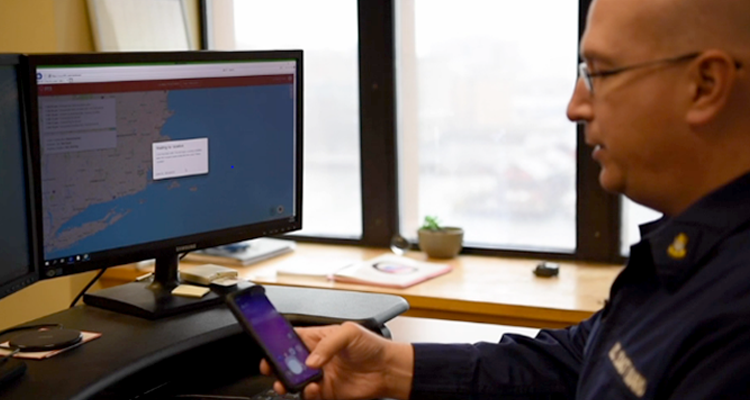
Chief Dwain McCullough, a command duty officer with Coast Guard Sector Boston, demonstrates how the i911 system works. U.S. Coast Guard photo by Petty Officer 2nd Class Nicole J. Groll.
The Coast Guard Office of Research, Development, Test and Evaluation and Innovation often focuses on identifying, researching and transitioning technologies that might be beneficial to the service’s operations. The recent transition to use of one such technology – called i911 – is already having a significant impact on Coast Guard search and rescue.
“It’s like Rescue 21 for the phone,” said Chief Petty Officer Andrew Case, a command duty officer at Sector Southeastern New England, located in Woods Hole, Massachusetts. “It greatly decreases the time we spend looking for someone and gets the rescue crews out faster.”
i911 pairs consumer smartphone technology with a web-based interface that Coast Guard command centers can use to locate distressed mariners. The technology uses the internal GPS of a cellphone to send the mariner’s location to a web-based map accessed by command center personnel. Its accuracy is often within a range of one to three meters.
The tool was approved for use this spring following a pilot program in 2019 conducted by the Coast Guard’s Research and Development Center (RDC). “i911 allows us to move directly to the rescue phase of search and rescue, providing reliable location information that allows Coast Guard crews to minimize the time necessary to locate and arrive on scene,” said Lt. Anne Newton, the RDC researcher who headed the project. It was initiated by the Office of Search and Rescue because Coast Guard personnel observed an increasing trend of cellphone use by mariners in addition to traditional tools like channel 16 VHF, the designated international marine distress frequency.
For example, Sector Honolulu Command Center reported that over the past three years, half of the search and rescue notifications received by Coast Guard District 14 had been made by phone calls to 911 or directly to the Coast Guard. These calls resulted in 534 lives saved, 1,300 lives assisted, over $10 million in property saved and $33.5 million in property assisted. This new technology will allow responders to find these mariners in distress more quickly. “An accurate position eliminates the need to search and decreases the time needed for rescuers to get on scene to provide needed assistance,” said Lt. Meagan Bowis of Sector Honolulu Command Center.
The Coast Guard 9th District Command Center – which covers the Great Lakes – has already used i911 on several cases, according to Lt. Cmdr. Jodie Knox, who served as command center chief until her recent transfer. Water in the Great Lakes can remain dangerously cold much later in the season than expected, so response times are critical. In one case, i911 was used to locate a boat taking on water north of Avon Lake, Ohio. “They were able to send us the position via i911, which allowed us to get assets to their location within 30 minutes and save two lives,” Knox said.
The Coast Guard 13th District, which covers the Pacific Northwest, also is using i911. “While VHF radio remains the most reliable form of distress communication, this tool gives the Coast Guard another avenue to rapidly locate mariners in distress utilizing smartphone technology,” said Lt. Cmdr. Bolin Boyle, the 13th District’s command center chief.
i911 was created by Callyo, a St. Petersburg, Florida-based company that develops mobile technology for law enforcement investigators. It was identified for the pilot program after the RDC conducted extensive market research of available technologies, considering factors such as reliability and accuracy as well as ease of use for mariners.
The pilot program was not just a test-run of the technology; the RDC entered into a cooperative research and development agreement (CRADA) with Callyo, which allowed the two to work together to customize features based on Coast Guard needs. While some changes were as simple as customizing the text message and adding the Coast Guard logo and racing stripes, several features were added specifically to aid command center watchstanders with their search and rescue efforts, such as latitude/longitude formatting and download capabilities. Because of the CRADA, the RDC was also able to build in an account approval process for those who will have access to the information as a deterrent to misuse.
“It’s really cool technology and already helped us on numerous occasions with search and rescue,” said John Olsen, a command duty watchstander for Sector Long Island Sound, which was part of the pilot. During the test period they used i911 to assist in bringing home several mariners, including three people on an inflatable raft. High winds and strong sea currents prevented the occupants from paddling to shore after the raft was blown out to sea. With i911, watchstanders were able to utilize the only communications equipment in the raft, the occupants’ cellphones, to pinpoint the raft’s location about 6 miles offshore and send rescue crews.
Locating a mariner in distress is the most critical – and often most difficult – piece of search and rescue, Newton said. Coast Guard command center personnel traditionally use whatever resources they can find to get a fix on a boater’s location.
Command center personnel from Sector Boston, also part of the pilot program, were pleased when the tool was approved for general use by the Coast Guard Office of Search and Rescue and the Office of Shore Forces. They cited a case during the pilot period in which i911 helped them locate a disabled craft approximately 20 miles offshore. “What was interesting about this case is we gathered cellphone location data from the service provider. That data put the vessel approximately 15 miles from its actual position. Without i911, it would have been very difficult to locate him.”
Sector North Carolina has also successfully used the newly authorized i911 web tool. The sector command center received a VHF-FM transmission from a mariner on board a 33-foot Scout; both sunset and a storm system were approaching and his boat had lost one engine and the second was struggling to overcome the prevailing weather conditions. Without a GPS on board, the best location description he could provide was that he was in the Albemarle Sound – which is 60 miles long and up to 15 miles across, for a total area of 450 square miles. By getting the mariner’s cellphone number and inputting it into i911, the sector command center was able to get a GPS position that was updated every 30 seconds. The GPS location was used to broadcast a Marine Assistance Request and ultimately to dispatch Coast Guard assets to assist the vessel. “The GPS tracking of the mariner’s cellphone continued throughout the case and was a valuable situational awareness tool for the command center.”
i911 can also be useful in preventing unnecessary searches. Sector San Diego recently used it to resolve a digital selective calling distress alert they received in which they discovered that the information sent by the automated alert signal was two owners out of date. When there was no response to phone calls, command center personnel used i911 to first locate the person listed as the owner and then the person who had purchased the boat from the listed owner. “The second owner had also recently sold the vessel, and we used i911 again (following an unsuccessful phone contact attempt). The current owner responded right away and was able to confirm he was not in distress. It happened quickly enough that we did not launch a Coast Guard asset, saving us money in fuel and resources,” according to Sector San Diego watchstanders.
Depending on the cellphone service, i911 can determine the locations of mariners in distress from up to 15-20 nautical miles offshore. To determine the efficacy of this range, the RDC looked at more than 38,000 search and rescue cases across the contiguous United States over the past five years and found that nearly 90 percent of all cases took place within 20 nautical miles of shore.
The research has even positively impacted New London, Connecticut, where the RDC is located. Two paddle boarders were rescued by Coast Guard Station New London June 23, after they became disoriented in fog and stranded on Gates Island. A good Samaritan heard calls for help and used their boat to try and locate the people in distress. When they were unsuccessful, they notified watchstanders at Coast Guard Sector Long Island Sound, who used i911 to determine the position of the good Samaritan and set up a search area. The Station New London boatcrew was then able to locate the paddle borders and transport them to shore.
“The i911 project highlights the importance of research and development transition within the Coast Guard,” said Wendy Chaves, chief, Office of Research, Development, Test and Evaluation and Innovation. “This tool has the potential to have tremendous impact on the search and rescue mission and help the Coast Guard save lives.”
- - -
i911 is not a replacement for standard marine devices such as Electronic Position Indicating Radio Beacons and VHF radios but an additional tool to provide potentially lifesaving information from a mariner’s cell phone.
For more information: Research and Development Center program page and Research, Development, Test and Evaluation program page
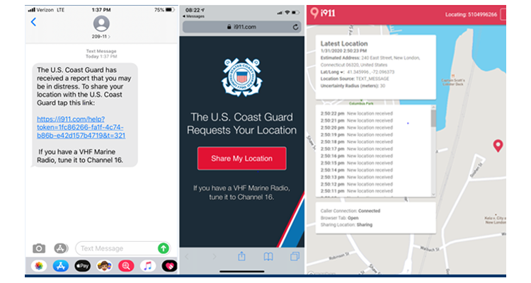
At left, a screenshot of the text message a boater in distress will receive from the U.S. Coast Guard. When the boater taps the link in the message, they are directed to the i911 site (middle), where they are asked to share their location. Once the boater taps the share button, i911 is able to pinpoint their location with an area of uncertainty of 1 to 3 meters (command center view at right). The tool requires no registration or downloading of mobile applications. U.S. Coast Guard graphic.