May 26, 2021 —
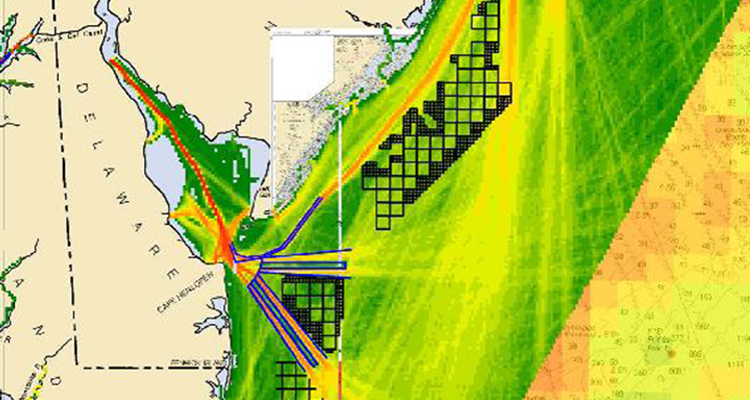
This map created from a digital tracking tool shows the density of maritime traffic in and out of Delaware Bay overlaid with black grid-blocks locating proposed wind energy areas off the coasts of New Jersey, Delaware and Maryland. The image is from the Atlantic Coast Port Assess Route Study undertaken by the Coast Guard to address potential navigational safety risks associated with offshore wind energy development. Graphic courtesy of National Oceanic and Atmospheric Administration/MarineCadastre.gov.
American coastlines are more than recreation and fishing destinations. They are vital to the development of trade and renewable energy. Sea space is finite so locating offshore infrastructure, such as offshore energy facilities, is a complicated balancing act. The Coast Guard provides input to the offshore energy development planning process because every change in the offshore environment has the potential to impact navigation safety.
In December 2020, the Coast Guard Research and Development Center (RDC) completed a multi-year project that supported those capability needs, and its recommendations are already being implemented operationally. The Department of Interior’s “Smart from the Start” initiative puts an emphasis on offshore renewable energy installations such as wind turbines. Anticipating an increase in the number and scope of these projects, the Coast Guard determined that reliable tools were needed to more accurately assess the associated potential changes in navigation safety risk.
“The Coast Guard has a responsibility to review offshore energy development plans because of the risks they may pose to the marine transportation system and Coast Guard missions,” said Christine Hansen, the RDC research lead on this project. “With increasing growth in this area of development, the Coast Guard must have the best tools and procedures in place to provide the best consultative review of the development proposals.”
Determining the risks – quantitative and qualitative tools
When a company proposes development of facilities, such as a wind farm in the offshore environment of the United States, all plans must be approved by the Bureau of Ocean Energy Management. Because of its unique perspective on the maritime environment and the potential impact the plans may have on its missions, the Coast Guard is part of the governmental review process. The Coast Guard identified the need to quantitatively measure navigation safety risk in the increasingly complex maritime development landscape, which led to the RDC project.
The Coast Guard wanted tools that would fully characterize how placement of structures and rerouting of marine traffic might affect safe navigation. The effects include the potential impacts of increased vessel traffic density, more restricted offshore vessel routing, fixed navigation obstructions and underwater cable hazards. Thorough knowledge of the area’s shipping/commercial uses and its recreational uses and port operations also had to be included in the decision-making process. After exploring both commercial and government off-the-shelf analytical modeling tools, the RDC determined that the International Association of Marine Aids to Navigation and Lighthouse Authorities Waterways Risk Assessment Program (IWRAP) was the best quantitative analysis tool for calculating navigation safety risk in terms of collisions, allisions and groundings.
Working closely with the Coast Guard Navigation Center, the RDC developed an IWRAP user guide to optimize the use of the tool to conduct the quantitative risk assessment. The IWRAP simulation modeling tool compares the risk in the waterway with and without the energy project in place and provides the change in risk as the quantitative measure.
Another component of the RDC project was developing a qualitative review process -- the project review panel (PRP) -- which utilizes Coast Guard subject matter experts in the evaluation. The PRP’s goal is to ensure consistency across different developments while accommodating unique situations and ensuring Coast Guard mission impacts have been appropriately considered. The PRP review process was formalized with detailed steps and a comprehensive checklist, which clarified the units responsible for each potential problem. Recommendations and identified gaps can be added as part of the documentation.
The final component of the project was establishing an overarching process to define how the navigation safety risk assessment tools fit into the overall offshore energy development process. “The quantitative analytical tool calculates the navigation safety risk and allows the Coast Guard to check the developer’s calculations in a rigorous, repeatable, quantitative manner,” Hansen said. “The second qualitative tool assesses the Coast Guard-proposed response to ensure consistency, continuation of mission capability and the concurrence of engaged Coast Guard offices.“
The project sponsor, the Coast Guard Office of Navigation Systems Navigation Standards Division, has adopted both the quantitative and qualitative navigation risk assessment tools proposed by the RDC. The Coast Guard Navigation Center has stood up the capabilities to use the quantitative tool and provide analytical risk assessment consultation to the project teams. With the completion of alpha testing, the qualitative tool will be used in the next project review.
“Having a standardized, repeatable process for assessing risk that is consistent no matter where the development is in the United States is very important for the Coast Guard’s review process,” said George Detweiler of the Navigation Standards Division. “These tools provide the potential for a great reduction in risk by bringing the strength of Coast Guard analytics and subject matter expertise to the assessment to ensure that all facets are considered.”
For more information: Research, Development, Test and Evaluation program page and Research and Development Center page.